The Power House Visitors’ Center is headquarters for Arizona’s Route 66 Association and has a nice museum and gift shop. For this road trip, we have planned to give Arizona not only our moral support but also financial support by spending extra nights in the State, shopping at local stores and making purchases at visitors' gift shops.
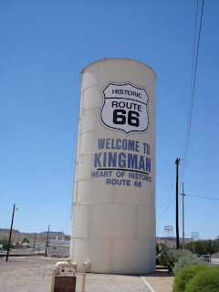 Monday, June 28th, at 12:47 p.m., we finally reached two of Route 66 most famous towns, Seligman and Kingman. Once you see this tower, there would be no mistake that you are in Kingman, Arizona.
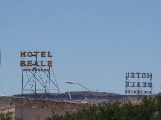 Above is the Hotel Beale sign, opened in 1899, still standing after more than 100 years.
Below is the Hill Top Motel (1954) still has its 1950s charm and the best view of the Hualapai Mountains. Below is Route 66 Motel still has the great flashing arrow neon sign. It was known as the Pony Soldier Motel of Kingman.
 Seligman was previously known as Prescott Junction, where the Prescott and Arizona Central Railroad met the Atlantic and Pacific Railroad (now the BNSF). The town was renamed Seligman after a prominent New York banker, Jesse Seligman, came to town, financed the railroad construction and decided that Prescott Junction should be re-named since Mr. Seligman brought such prosperity to the town.
 Roadkill 66 Café where roadkill is always fresh! Step inside and you would be transported back to an old west saloon with pictures, antiques and a large display of hunting trophies! The menu includes items such as Tire Tread Buff (Buffalo Burger),The chicken that Almost crossed the road (Fried Chicken), Road Side Remnants (Popcorn Shrimp) and Long Gone Fawn (6 oz. Steak).
  Historic Route 66 Motel, above, formerly named the Navajo Motel, went thru a complete renovation in recent years.
Below is Westside Lilo’s Café features American and German cuisine. Who would have thought finding German cuisine in Seligman, Arizona?
 Thanks to local barber Angel Delgadillo and other founders of the Arizona Historic Route 66 Association, who recognized that the heritage of Route 66 was vital to America’s history. Their hard work in keeping the Mother Road alive and “kicking”, so that Americans and people from around the world were able to experience the real charm of Main Streets of America.
 Copper Cart is one of the vintage restaurants along the stretch of Route 66 running through downtown Seligman.
 Monday, June 28th, at 10:15 a.m. we continued our westward trip thru Williams, Arizona. The town was named for Bill Williams, a well-known fur trapper, one of the first white settlers in the area.
 Williams known as the Gateway to the Grand Canyon, due to the Grand Canyon Railway which offers train rides in restored 1880s coaches, pulled by a vintage steam engine, for daily visits to the Grand Canyon National Park. Until 1927, more than half of the visitors to the canyon boarded the railway from Williams to the south rim.
 Williams also is known as the last town to be bypassed by the interstates. Once the construction of the I-40 is completed, on October 13, 1984, people were able to drive from Chicago to California, non-stop on interstates, without encountering a single traffic light.
 Mr. Bill Williams standing tall, looking as if he was pleased with his latest trade!
 Twisters, is a Route 66 souvenirs shop, serving chocolate sundae, and features retro-50 soda fountains.
Rod’s Steak House, has been serving steaks since 1945.


 Above is the Red Garter Bed and Bakery, an 1897 bordello structure. Look closely and you will see the “lady” leaning out a window, waiting for any “gentleman” might be looking for entertainment for the evening.
 Part of the fun when travelling Route 66 is to find vintage items such as this neon Cocktails and Package Goods sign.
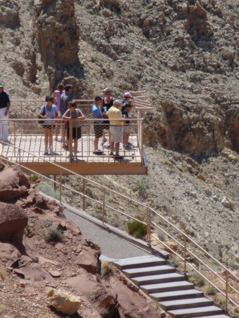
 “Grand Canyon – one of Earth’s most powerful, inspiring landscapes – overwhelms our senses”, these words from the visitors guide published by the National Park Service was exactly how I felt when we got our first glimpse of the canyon from Mather Point on the South Rim at 3:19 p.m. on Sunday, June 27, 2010.
 It was an astounding experience. The Canyon was so beautiful and so majestic, beyond my imagination and yet so familiar from having seen documentaries and looking at images in printed materials. Here we are, at the Grand Canyon, one of the seven natural wonders of the world. Nearly 2 billion years of geologic history, layers of limestone exposed, eroded by natural elements of water and wind, so gentle yet so powerful.
 If the Grand Canyon is a sculpture garden, then God must be the best artist to create such masterpiece.
 Borrowing the words of wisdom from Forest Gump, "when standing at the Grand Canyon, the view is so vast, as far as the eye can see, I don't know where the earth ends and where heaven begins!".
 Driving along Hermit Road, after a few stops at the overlooks, I decided that I should put away my camera and just enjoyed the views. There are only great photos of the canyon, no matter what camera or the person taking the photos. The canyon is like a gorgeous woman who needs no artificial make-up or fancy dresses. A person could close his eyes and still take great photos of this amazing landscape.
 "How could it possible be so beautiful", it was the thoughts that kept running thru my mind.
 The view from any of the nine overlooks was spectacular, breath-taking in literally sense. At times I felt as if I was floating on air, flying over the canyon, touching the colorful layers of limestones, up-close and personal with the dramatic view of the rock formations, the multihued stone walls, and dipping my toes into the Colorado Rivers, thousand miles deep below the canyon. The Rivers looks like a tiny stream when standing at the edge of the canyon but it is nearly 350 feet wide, meanders west through the Canyon.
 At 7:35 p.m. we followed the crowd into Canyon Café as it was time for dinner. We were hungry since we only had a sandwich at the Meteor Crater, almost 7 hours ago. We decided to get overnight accomodation at Yavapai Lodge, a motel-style lodge at the eastern end of the Canyon, approximately ¼ mile from the South Rim. I learned that the word Yavapai means “sun people” in Paiute, a group of nomadic native people associated with the Grand Canyon.
 We planned to get up early for the sunrise views when the colors of the rock deepen dramatically among the layers of the canyon walls. Well, we did not get up early but the next morning, at 7:28 a.m. the view was still much more beautiful than we could expect. Since it was early, at one of the points, we almost had the whole canyon all for ourselves, without any other visitors around. We left the canyon at around 8:50 a.m. on Monday, June 28th, with a promise that we would be back soon to visit the North Rim and stay longer. Grand Canyon National Park will be on our top-10 list of the best and the most memorable places.
 Above is the view from our room at Yavapai Lodge.
 As I am trying to re-capture the details of our Route 66 Adventure, I realized that the time shown on the photos did not match the time in the admission tickets and the receipts. On Sunday, June 27th, our next stop after Winslow was Meteor Crater. The time on the admission tickets was 10:05 a.m. (I am sure they keep very accurate time at the Crater) while the photos showed 11:15 a.m. (It probably because the camera did not change according to the time zone.)
 Meteor Crater is located about 6 miles south of I-40 at exit 233. The crater was created approximately 50,000 years ago when a meteorite 150 feet across, weighing 300,000 tons, made an impact that left a huge hole, a size that would fit 20 football fields, in the desert. We learned that the Crater is the largest and best-preserved crater on the planet, 570 feet deep, one mile cross, and 3 miles in circumference.
 We stopped at the snack bar for sandwiches, then walked around the interpretive exhibit, the gift shop and joined others on the observation platforms for a self-guided tour of the crater. We decided not to join the guided tour of hikers around the crater after we saw a woman who was in pains from a sprained ankle, being carried in a wheelchair by the tour guide.
 At first I thought it was a mural of the San Francisco Peak but someone must have a clever idea to put this opening there to give visitors a great view of the mountain.
 Not wanting to disappoint Bobby Troup, we did not forget Winona. Below is the Walnut Creek Bridge (built in 1925), a steel truss bridge, sometimes called the Winona Bridge. The bridge was featured in the 1994 film Forest Gump.
 According to our original plans, at this point of the trip we were supposed to be heading toward Monument Valley in Utah. But then we decided to continue on to the Grand Canyon National Park. Somewhere along the way, I don’t remember what happened but somehow we “flew” by Flagstaff and I don’t have any photos to prove that we were there! Flagstaff will definitely be on the list of our next road trip.
 Sunday, June 27th – Another 6:00 a.m. rise and shine! After checking out of the hotel, we took a slow drive around downtown Holbrook taking photos of the many Route 66 era businesses, some that are still striving while others were just remnants of that forgotten bustling city.
  We found a Catholic church but the earliest Mass was scheduled at 9:00 a.m. and we thought it would be best to attend Mass at the next town. (Back in the 1800s, Holbrook was once known as the town that was too tough for churches because it was the only county seat in the nation without a church! Not that this information had any impact on our decision not to attend Mass in this town with the infamous Bucket of Blood Saloon.)

 We stopped briefly in Joseph City to take photos of the Jackrabbit Trading Post and one of the most famous sign of Route 66, the wooden sign “Here It Is” (below photo)
 I was about to sit on this giant jackrabbit (below photo) but it ran away screaming, “Not you, chubby woman!”.

 This monument (above photo) greeted us as we arrived in Winslow. The 9-11 Remembrance Garden is located at the east end of town. The two steel beams are from the World Trade Center terrorist attack and the U.S. flag was flown at the Pentagon on September 11, 2001.
 Above photo - At Kinsley and 2nd is the “Standing on the Corner” sculpture (Ron Adamson was the artist) and a mural of “a girl in a flat bed Ford” painted on the side of building, just like the lyrics from The Eagles song Take It Easy (1972). An authentic red flatbed Ford truck parked nearby.
 This southwestern hotel La Posada Hotel (built in 1928), restored in the 1990s, was a former Harvey House designed by famed architect Mary Jane Colter. It was so charming that I just wish we could have spent a night there. It definitely would be on our “must experience” list for the next Route 66 road trip.
 Leaving Winslow at 10:20 a.m., we continued to travel west on I-40, took exit 239 – Meteor City, to see the mural above, the World’s Longest Map of U.S. Route 66 painted on the side of a geodesic dome building. What is the name of the building? Meteor City Trading Post, what else?
 Not sure if this giant dream catcher (below) helped or we were so tired from the constant stop and go at all the attractions but I did have a very good sleep that night.

 The Power House Visitors’ Center is headquarters for Arizona’s Route 66 Association and has a nice museum and gift shop. For this road trip, we have planned to give Arizona not only our moral support but also financial support by spending extra nights in the State, shopping at local stores and making purchases at visitors' gift shops.
 Monday, June 28th, at 12:47 p.m., we finally reached two of Route 66 most famous towns, Seligman and Kingman. Once you see this tower, there would be no mistake that you are in Kingman, Arizona.
 Above is the Hotel Beale sign, opened in 1899, still standing after more than 100 years.
 Seligman was previously known as Prescott Junction, where the Prescott and Arizona Central Railroad met the Atlantic and Pacific Railroad (now the BNSF). The town was renamed Seligman after a prominent New York banker, Jesse Seligman, came to town, financed the railroad construction and decided that Prescott Junction should be re-named since Mr. Seligman brought such prosperity to the town.
 Roadkill 66 Café where roadkill is always fresh! Step inside and you would be transported back to an old west saloon with pictures, antiques and a large display of hunting trophies! The menu includes items such as Tire Tread Buff (Buffalo Burger),The chicken that Almost crossed the road (Fried Chicken), Road Side Remnants (Popcorn Shrimp) and Long Gone Fawn (6 oz. Steak).
  Historic Route 66 Motel, above, formerly named the Navajo Motel, went thru a complete renovation in recent years.
 Thanks to local barber Angel Delgadillo and other founders of the Arizona Historic Route 66 Association, who recognized that the heritage of Route 66 was vital to America’s history. Their hard work in keeping the Mother Road alive and “kicking”, so that Americans and people from around the world were able to experience the real charm of Main Streets of America.
 Copper Cart is one of the vintage restaurants along the stretch of Route 66 running through downtown Seligman.